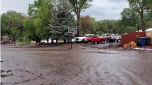
Photo provided by Shannon Benjamin, Owner, Anderson General Tire and Flagstaff resident of a 2021 Flagstaff AZ flash flood
Sedona AZ – Coconino County announced today that updated digital flood hazard maps for Coconino County, Yavapai County, and the city of Sedona sections of Oak Creek, are available for public review and comment. These maps, known as Flood Insurance Rate Maps (FIRMs), show the extent to which areas recently remapped in Oak Creek and its tributaries are at risk for flooding. The maps cover the area from Sterling Canyon in Coconino County, through the city of Sedona and further down to Cornville. Used to help determine flood insurance and building requirements, the new flood maps replace maps based on studies more than 30 years old.
Residents and business owners can use the maps to obtain reliable information about their current flood risk on a property-by-property basis. The maps provide flood zone and elevation data to help community planners, engineers, builders and others decide where and how new structures, developments, and remodeling projects should be built. Information about the mapping project and how to view the preliminary maps is found at www.YavapaiAZ.gov/OakCreekMaps(link is external).
Separate virtual online Flood Risk Open House meetings are also being held for residents and business owners in the Coconino County and Yavapai County areas of Oak Creek to learn more about the project and how to view the maps.
“Flooding is an increasingly frequent and costly problem throughout this part of Arizona, and not just in high risk areas,” said Lucinda Andreani, Deputy County Manager and Coconino County Flood Control District Administrator. “Having more accurate and easily accessible maps is an important step in understanding the risk, so residents can take steps to mitigate the risk and insure against it. That said, all property owners in Coconino County should strongly consider purchasing flood insurance given that major monsoonal rainfall events like experienced throughout the County this year can occur at any time and can cause serious flooding impacts. Flood insurance is the only source of securing reimbursement for addressing flooding impacts.”
 The maps were developed by the Yavapai County Flood Control District along with the Federal Emergency Management Agency (FEMA) and in partnership with Coconino County Flood Control District and the City of Sedona. The process included an extensive multi-year review of the changes brought about by environmental, land use, and other forces, using state-of-the-art aerial mapping and risk modeling techniques, as well as, new scientific data and a comprehensive prerelease review.
In reviewing the maps, some property owners in Oak Creek will find that their risk is higher or lower than they thought. If the risk level for a property changes, flood insurance and building standards requirements can change as well. FEMA’s National Flood Insurance Program has cost saving rating options to help reduce the cost of flood insurance for property owners whose flood risk has changed.
An online Virtual Flood Risk Open House has been scheduled so residents in the Coconino County section of Oak Creek can learn how to view the new maps, understand how their properties may be affected, review options they may have, and learn more about financial and material steps necessary to protect their investments:
Coconino County Virtual Flood Risk Open House – Wednesday, Sept. 15, 2021,
6:30 p.m. – 8:00 p.m.
Go To Webinar
Link: https://bit.ly/OakCreekSept15(link is external)
Phone: +1 (631) 992-3221
Access Code: 846-224-538
 More information about the Open House is available at the project website: www.YavapaiAZ.gov/OakCreekMaps(link is external). For those unable to attend, a livestream recording will be posted on this website.
The updated FIRMs are still preliminary, and have not been officially adopted nor become effective yet. In addition to the virtual public meeting, there will be a Public Comment Period, targeted to run September 29 – December 28, 2021, where property owners can comment submit appeals, if they can show that the maps are technically or scientifically in error.
Once all appeals and comments are received and addressed, the maps are expected to become effective in 2022. At that time, the new flood insurance requirements will take effect.
Coconino County residents can learn more about the remapping project, view the new preliminary flood maps and find the schedule and link to the upcoming meeting at www.YavapaiAZ.gov/OakCreekMaps(link is external).
Individuals with general questions about the local map update efforts can also call the Coconino Flood Control District at 928-679-8300 during business hours or email FEMAFloodMap@coconino.az.gov(link sends e-mail).
For information about flood insurance, contact your local insurance agent or visit www.FloodSmart.gov(link is external).


Thanks a lot for sharing the flood maps, it helps me complete my project.