 Sedona AZ (May 25, 2014) – The following is the ORDER SLIDE FIRE EMERGENCY CLOSURE COCONINO NATIONAL FOREST:
Order Number: 04-14-05-F
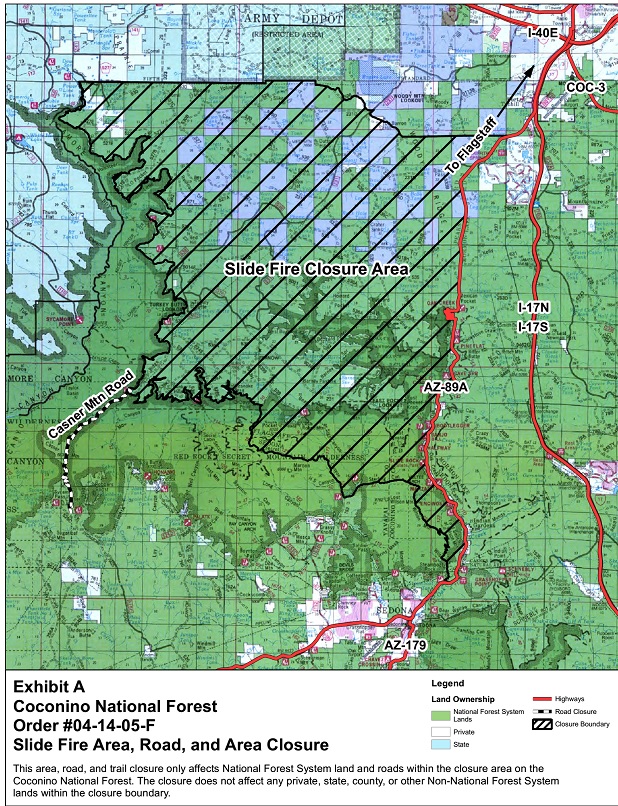
Pursuant to 16 U.S.C. 551, and 36 CFR § 261.50(a) and (b), the following acts are prohibited on all National Forest System lands within the Coconino National Forest, in Coconino and Yavapai County in the state of Arizona. The restricted area is depicted on the attached map, hereby incorporated into this Order as Exhibit A.
PROHIBITIONS:
1. Going into or being upon the restricted area; 36 CFR § 261.52(e)
2. Being on the road; 36 CFR § 261.54(e)
3. Being on a trail; 36 CFR § 261.55(a)
EXEMPTIONS:
Pursuant to 36 CFR § 261.50(e), the following persons are exempt from this closure order:
1. Persons with a Forest Service permit specifically authorizing the prohibited act or omission.
2. Any Federal, State or Local Officer or member of an organized firefighting force in the performance of an official
duty.
3. Resident owners will be allowed to drive to and from their residence.
AREA DESCRIPTION:
Beginning at the corner of Section 19 of the Northeast corner, Township 20 North, Range 6, East, west to Forest Road (FR) 231 (Woody Mtn.) and FR 231D in T20N R5E in the NE corner of S7, then NW along FR 526 to the Navajo Army Depot boundary junction and then westerly along the Forest Boundary (FB) to the boundary with the Kaibab NF in T20 R4E NW corner of S 4, then SE along the Sycamore Wilderness Boundary to the Taylor Cabin Trailhead T18 R4E center of S35.
Casner Mt. Trail # 8 is closed from the TH to its southern terminus at FR525C. Continuing from the Taylor Cabin TH easterly along the RR Secret Mt. Wilderness Boundary to Secret Canyon Trail #16 junction, then southerly along the Secret Canyon Trail to the bottom of Secret Canyon and then easterly to FR 152 at T18 R5E NW corner of S23, then easterly to the junction with Vultee Arch Trail #22, following Trail #22 east to
the junction of the Wilson Mountain Trail, following the trail south on the Wilson Mountain Trail to Midgley Bridge and Hwy 89A, from Highway 89A following 89A north to the beginning.
This area, road and trail closure only affects National Forest System land, roads and trails within the closure area on the Coconino National Forest. The closure does not affect any private, state, county or other Non-National Forest System lands within the closure boundary.
PURPOSE:
This Order is necessary to protect public health and safety due to ongoing wildfire and rehabilitation on the Slide Fire.
IMPLEMENTATION:
1. This Order will be in effect when signed and shall remain in effect until August 31, 2014 or until rescinded,
whichever occurs first.
2. This Order rescinds, replaces and supersedes any previous Orders prohibiting the same acts covered by this Order
in that area addressed in Exhibit A
0 1.5 3 4.5 6 7.5
Miles
AZ-89A
I-17S
I-17N
I-40E
COC-3
AZ-179
Slide Fire Closure Area
Casner Mtn Road
Exhibit A
Coconino National Forest
Order #04-14-05-F
Slide Fire Area, Road, and Area Closure
This area, road, and trail closure only affects National Forest System land and roads within the closure area on the Coconino National Forest. The closure does not affect any private, state, county, or other Non-National Forest System lands within the closure boundary.
Closure Boundary
For the best Arizona news and views, read www.SedonaEye.com daily!


Liked and shared this article on Facebook.
Liked this article on Facebook.
Liked this article on Facebook.
Liked and shared this article on Facebook.