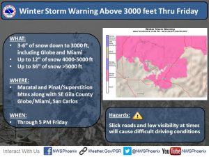
 Sedona AZ – Multiple stretches of Arizona’s highways were closed as of Thursday afternoon, February 21, due to a powerful winter storm whose fury continues across much of the state.
With the heavy weather expected to last into Friday and snow forecast to extend into southeastern Arizona overnight, the safest option remains delaying travel to and through higher elevations until the Arizona Department of Transportation’s plows have cleared highways of snow and ice. Motorists in lower elevations may see some snow along with considerable rainfall.
Wherever they travel in whatever weather they face, motorists should slow down for safety and expect the unexpected. Those traveling in areas with snow and ice should give ADOT’s plows plenty of room to work, staying at least four vehicle lengths behind and never passing a working plow until the operator pulls over to let traffic pass.
As of 4:15 p.m. Thursday, these were the major highway restrictions around Arizona. Because the situation remains dynamic, the best way to keep track of highway closures, restrictions and conditions is following ADOT’s Twitter account at (@ArizonaDOT), calling 511, using the free ADOT Alerts app available at ADOTAlerts.com and visiting the Arizona Traveler Information site at az511.gov.
A pop-up alert on ADOT’s homepage, azdot.gov, has an updated list of major closures:
 I-17 northbound at State Route 179, milepost 298
I-40 eastbound at State Route 95, with traffic detouring south on SR 95
Both directions of State Route 87 between State Route 188 and Payson, mileposts 238-250, and between Payson and Winslow, mileposts 254-337
Both directions State Route 260 between Star Valley and Heber-Overgaard, mileposts 256-302, and eastbound State Route 260 east of milepost 228 near Interstate 17
Both directions of SR 89A between Sedona and Flagstaff, mileposts 375-398.
If decide to travel, slow down for safety, budget plenty of time, and leave prepared for the possibility that you will be delayed by closures related to weather and crashes.
Four-wheel-drive vehicles and chains are recommended in areas with heavy snow.
ADOT has winter driving tips available at azdot.gov/KnowSnow.


There is ‘Snow’ place Like Home… and it will be the best place to stay over the next 48 hours. – UPDATED
…We are looking forward to upward of 18 inches of snow over the next two days. Be prepared. Don’t travel unless necessary. Be safe out there!…
Bryan Thomas
Community Relations Officer
Yavapai County Sheriff’s Office
255 E. Gurley St. Prescott, AZ 86301
Bryan.Thomas@yavapai.us
Update: Powerful winter storm hampers travel across much of Arizona
With snow continuing to fall, putting off travel is safest option
Sedona AZ – Multiple stretches of state highways were closed as of Thursday evening, Feb. 21, due to a powerful winter storm that continued across much of Arizona.
With heavy weather expected to last into Friday and snow forecast to extend into eastern and southeastern Arizona overnight, the safest option remained delaying travel to and through higher elevations until the Arizona Department of Transportation’s plows have cleared highways of snow and ice. Motorists in lower elevations may see some snow along with considerable rainfall.
Wherever they travel in whatever weather they face, motorists should slow down for safety and expect the unexpected. Those traveling in areas with snow and ice should give ADOT’s plows plenty of room to work, staying at least four vehicle lengths behind and never passing a working plow until the operator pulls over to let traffic pass.
As of 9:15 p.m. Thursday, these were the major highway closures around Arizona. Because the situation remains dynamic, the best ways to keep track of highway closures, restrictions and conditions are following ADOT’s Twitter account at (@ArizonaDOT), calling 511, using the freeADOT Alerts app available at ADOTAlerts.com and visiting the Arizona Traveler Information site at az511.gov.
A pop-up alert on ADOT’s homepage, azdot.gov, has an updated list of major closures:
I-17 northbound at State Route 179, milepost 298
Both directions of State Route 87 between Payson and Winslow
Both directions State Route 260 between Star Valley and Heber-Overgaard, mileposts 256-302, and eastbound State Route 260 east of milepost 228 near Interstate 17
Both directions of SR 89A between Sedona and Flagstaff, mileposts 375-398
US 60 between Superior and Miami and between State Route 73 and Globe
State Route 77 between Globe and Winkelman
State Route 177 between Superior and Hayden
If you decide to travel, slow down for safety, budget plenty of time and leave prepared for the possibility that you will be delayed by closures related to weather and crashes. Four-wheel-drive vehicles and chains are recommended in areas with heavy snow.
ADOT has winter-driving tips available at azdot.gov/KnowSnow.
NOAA-NWS-ALERTS-
Sent: 02:43 MST on 02-22-2019
Effective: 02:43 MST on 02-22-2019
Expires: 17:00 MST on 02-22-2019
Event: Winter Storm Warning
Alert:
…WINTER STORM WARNING REMAINS IN EFFECT UNTIL 5 PM MST THIS AFTERNOON…
* WHAT…Periods of moderate to heavy snow will continue. Plan
on difficult travel conditions. Additional snow accumulations
of 3 to 6 inches.
* WHERE…Areas near Buffalo Pass, Chinle, Dilkon, Eagar-
Springerville, Ganado, Holbrook, Kayenta, Kykotsmovi, Page,
Saint Johns, Shonto, Snowflake-Taylor, Tuba City, Window Rock
and Winslow.
* WHEN…Until 5 PM today.
* ADDITIONAL DETAILS…Look for significant reductions in visibility at times.
Additional snow forecast from 2 AM Today to 5 PM Today:
Buffalo Pass 3 to 5 inches Chinle 1 to 3 inches
Dilkon 3 to 5 inches Eagar-Sprgrvlle 4 to 6 inches
Ganado 3 to 5 inches Holbrook 2 to 4 inches
Kayenta 2 to 4 inches Kykotsmovi 2 to 4 inches
Page 0 to 1 inches Saint Johns 2 to 4 inches
Shonto 2 to 4 inches Snowflake-Taylor 3 to 5 inches
Tuba City 1 to 3 inches Window Rock 3 to 5 inches
Winslow 2 to 4 inches
Instructions:
A Winter Storm Warning for snow means severe winter weather conditions are occurring. If you must travel, keep an extra flashlight, food and water in your vehicle in case of an emergency.
The latest road conditions for the state you are calling from can be obtained by calling 5 1 1.
Target Area:
Black Mesa Area
Chinle Valley
Chuska Mountains and Defiance Plateau
Little Colorado River Valley in Apache County
Little Colorado River Valley in Coconino County
Little Colorado River Valley in Navajo County
Marble and Glen Canyons
Northeast Plateaus and Mesas Hwy 264 Northward
Northeast Plateaus and Mesas South of Hwy 264
Forecast Office: Flagstaff AZ