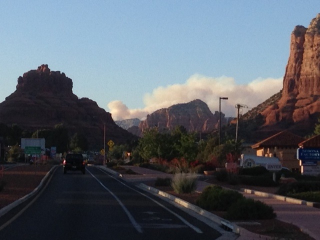
View of Slide Rock fire from Village of Oak Creek in Sedona at 6:45 PM photo credit SedonaEye.com
Acreage estimates and fire fighting operations will be updated in the comment section below this article as more information becomes available.
Multiple firefighting units have responded, including two Hotshot crews, four engines, two helicopters, an air attack unit and the Sedona Fire District.
Highway 89A is closed to traffic north of uptown Sedona, and south bound from Flagstaff, Arizona. Evacuations are being ordered for areas just north of Slide Rock State Park.
Structures are threatened and evacuations have been ordered. The fire is currently moving to the north and fuel treatments in the area have kept the fire from aggressive activity.
In addition, Arizona Interstate 17 is closed in both directions near Sunset Point north of Phoenix because of a brush fire, according to the Arizona Department of Transportation: The freeway is closed from mile 254 for northbound traffic to mile 262 for southbound drivers. The site is near the Sunset Point Rest Area about 35 miles north of Phoenix. There is no indication when the freeway will reopen.
For more on Arizona highway conditions visit ADOT’s Travel Information site at az511.gov or call 5-1-1. Updates are also available on the ADOT Twitter feed (@ArizonaDOT) and on Facebook.
For the best in Arizona news and views, read www.SedonaEye.com daily!


Slide Fire in Oak Creek Canyon – U.S. Forest Service Update on 5/21/14 at 7:15 a.m.
The Slide Fire is located in Oak Creek Canyon just north of Slide Rock State Park and burning northward, up the canyon.
A small 4½ acre fire, the Cookstove Fire, was reported late last night 2 miles northeast of the Slide Fire and is presumed to have started as a spot fire from the larger Slide Fire. Firefighters were able to create a line around the Cookstove Fire with a dozer at approximately 2 a.m.
A Type I Incident Management Team has been ordered and is expected to arrive at approximately 3 p.m.
Law Enforcement is seeking any information the public may have regarding the start of the Slide Fire and anyone of suspicion in the area yesterday between Slide Rock State Park and Half Way Picnic Area. The public should call Forest Service Law Enforcement at 928-527-3511 if they have any information that might assist law enforcement in the investigation.
Fire activity is slowing toward the north and now concentrating on moving up the steep canyon walls. Resources are stationed above and below the fire.
Smoke is heavy through Oak Creek Canyon and creating very hazy conditions in Flagstaff. Smoke will likely continue to drift north and be noticeable along I-17 as motorists approach northern Arizona.
Size: Approximately 400-450 acres
Containment: 0%
Location: Originated just north of Slide Rock State Park, approximately 4 to 5 miles north of Sedona.
Date Reported: Tuesday, May 20 at approximately 4 p.m.
Cause: Human caused, under investigation
Current Resources: Approximately 200 personnel including five hotshot crews, three helicopters, one air attack, 10 engines, two water tenders, Sedona Fire, a fuels crew and two dozers.
Ordered Resources: One Type 1 Incident Management Team, one air tanker en route, 15 hotshot crews, 10 Initial Attack crews, 40 engines and additional overhead personnel.
Closures: Highway 89A from Sedona to Fort Tuthill in Flagstaff. Forest Road 535 off Highway 89A. Power has been shut off by APS from Slide Rock, north through the canyon.
Evacuations: An approximate 2 to 3-mile stretch of area from Slide Rock State Park north toward the Sterling Springs Hatchery has been evacuated, as well as the East Pocket Forest Service Lookout Tower. Evacuees are being relocated to Sinagua Middle School in Flagstaff.
Structures Threatened: Approximately 100 structures are currently threatened north of Slide Rock State Park, which include private homes as well vacation resort cabins and a Forest Service Lookout tower.
Injuries: No injuries reported.
Liked this article on Facebook.
Liked this article on Facebook.
Slide Fire in Oak Creek Canyon – U.S. Forest Service Afternoon Update on 5/21/14 Posted Date: 5/21/2014 12:30 PM
The Slide Fire is located in Oak Creek Canyon just north of Slide Rock State Park and burning northward, up the canyon into places such as West Fork and Harding Point.
Overview: Firefighters are concentrating on keeping the fire west of Highway 89A, minimizing impacts to structures and utilizing terrain and fuel features to fight the fire. Smoke is heavy through Oak Creek Canyon and creating very hazy conditions in Flagstaff as the smoke moves mostly in a northern directly. Smoke will likely continue to drift north and be noticeable along I-17 as motorists approach northern Arizona.
Winds are expected to be approximately 10-12 mph in Oak Creek Canyon today and gusts of 30 mph above the rim of the canyon.
A Type I Incident Management Team has been ordered and is expected to arrive at approximately 3 p.m. Public information will be handled by the team and new points of contact for Slide Fire information will be sent to members of the media once the team is established.
Law Enforcement is seeking any information the public may have regarding the start of the Slide Fire and anyone of suspicion in the area yesterday between Slide Rock State Park and Half Way Picnic Area. The public should call Forest Service Law Enforcement at 928-527-3511 if they have any information that might assist law enforcement in the investigation.
Information regarding the Slide Fire will be updated on Inciweb as it becomes available: http://inciweb.nwcg.gov/incident/3874/
Size: Current official size is 850 acres. However, acreage is expected to grow throughout the day and reach approximately 1,000 to 2,000 acres by nightfall. An accurate acreage count is usually determined by overflights that are conducting at night, so the next official acreage may not be available until the following morning of the flights.
Containment: 0%
Location: Originated just about 4 to 5 miles north of Sedona, just north of Slide Rock State Park.
Date Reported: Tuesday, May 20 at approximately 4 p.m.
Cause: Human caused, under investigation
Current Resources: Approximately 200 personnel including five hotshot crews, three air tankers, three helicopters, one air attack, 10 engines, two water tenders, Sedona Fire, a fuels crew and two dozers.
Ordered Resources: One Type 1 Incident Management Team, 15 hotshot crews, 10 Initial Attack crews, 40 engines, one light helicopter and additional overhead personnel.
Closures:
Highway 89A from Sedona to Fort Tuthill in Flagstaff
Forest Road (FR) 535 at Highway 89A
FR 533 at Highway 89A
FR 231 at Rogers Lake
FR 527 and 530 (west side; Volunteer Canyon area)
Casner Mountain is closed to all vehicles.
Evacuations: An approximate 2 to 3-mile stretch of area from Slide Rock State Park north toward the Sterling Springs Hatchery has been evacuated, as well as the East Pocket Forest Service Lookout Tower. Evacuees are being relocated to Sinagua Middle School in Flagstaff. There is no count as to how many individuals have been evacuated.
Structures Threatened: Approximately 100 structures are currently threatened north of Slide Rock State Park, which include private homes as well vacation resort cabins and a Forest Service Lookout tower.
Injuries: No injuries reported.
Per CBS news at noon… 850 acres have been burned. Garland’s Lodge was saved because the owners had prepared with water tanks and a system to protect the property, which allowed fire fighters to make a stand there.
Not sure about Banjo Bills which is just below Garland’s on the creek, and a place I go weekly. On a personal note I was very upset last Friday when at Banjo Bills, I saw that none of the bar-b-que pits had been tied closed, local wood had been burned in them and burned on the ground, and cigarette butts were laying all over the ground burned in place, no notice on board that said anything that tourists could read about the fire dangers. This was after the busy Mother’s Day weekend, where there is only infrequent, quick drive through’s by a ranger.
I’m so sad right now.
Due to the Slide Fire in Oak Creek Canyon, and for obvious reasons, the emergency siren system testing previously scheduled for tomorrow at 10:00 AM has been cancelled. The sirens were “tested” yesterday in an actual emergency and worked fine.
Thank you.
Tricia Greer
Executive Assistant
Sedona Fire District
928-204-8909 (Direct Dial)
Liked this article’s updates on Facebook.
When do we say ENOUGH? When do we stop allowing campfires in and near our desert forests and in desert forest campgrounds?
When do we put quality of life, livelihoods, scenic vistas and wildlife above idiot tourists cooking hot dogs? When do we tell people that don’t know how to properly use bathroom facilities and take dumps on scenic paths or wash their hands and collect their own feces and garbage to get out and stay away? ASk us volunteers who cleaned up during the Oak Creek Watershed event. ASk why we in Sedona can’t hike a trail without being attacked by flies. Look for a dump pile! GROSS!
DROUGHT!! WE ARE DEEP IN A DROUGHT CYCLE THAT ISN’T DUE TO END FOR MANY YEARS. READ THE SCIENCE!!
Who s responsible for the lack of preparation, enforcement & promotion? want to enjoy the scenery then do it on foot and without matches and learn how Americans keep themselves clean, learn to use bathrooms or to leave no trace!! enough said because of deaf ears
Liked this article on Facebook.
Coconino County is reminding people to register their cell phone number with the County’s CodeRED emergency notification system at http://www.coconino.az.gov/emergency.
Only those residents whose numbers are registered will receive a direct phone call about any type of pre- or mandatory evacuation order.
Pre-Evacuation Warning Given to Kachina Village, Forest Highlands Residents
Incident: Slide Fire Wildfire
Released: 29 min. ago
Coconino County has issued a pre-evacuation warning for residents in Kachina Village and Forest Highlands subdivisions. There has not been a mandatory evacuation given at the time of this release.
Residents at this time are advised to prepare to evacuate from their homes. County Emergency Management encourages those in the affected neighborhoods to begin packing important items they may need for several days. These items include prescriptions, important papers, any special dietary needs and pets.
The County has set up a call center for the public to obtain general information about the impacts of the Slide Fire. For additional information, call 928-679-4173.
Residents will be given advanced warning when any further action is required. If a mandated evacuation is to take place, residents will be notified via the CodeRed emergency system and Coconino Sheriff uniformed deputies will go door-to-door to evacuate residents.
Officials have set up an evacuation center located at Sinagua Middle School at 3950 E Butler Ave. in Flagstaff. A shelter for pets has been set up at the Coconino Humane Association 3501 E. Butler Ave.
The County is reminding people to please register their cellphone number with the County’s CodeRED emergency notification system at http://www.coconino.az.gov/emergency. Only those residents whose numbers are registered will receive a direct phone call about any type of pre- or mandatory evacuation order.
Due to smoke in the greater Flagstaff area, the public is asked to limit their exposure outside. The County Public Health Services District advises the public that if they feel ill as a result of wildfire smoke to please take necessary precautions. Some tips for those that feel ill would be to stay indoors, use a HEPA filter and limit your activities and contact your health care provider for additional instructions.
There will be another “Special City Council Meeting” tomorrow (5/22).
The first order of business is more discussion on usage of Development Impact Fees. Do you suppose this will include what’s been going on in executive sessions? That being researching purchase of the Lomocasi Resort property for the ongoing pursuit of a Creek Park/Walk?
Next:
AB 1805 Informational update/discussion/possible action related to the Slide Fire in Oak Creek Canyon.
This agenda item is intended to provide an opportunity for informing the City Council and Sedona citizens of the latest developments concerning this local disaster. The Council may discuss and take any action it deems necessary within its powers in order to facilitate the preservation of life and property. Actions may include but not be limited to seeking emergency declarations from the State and Federal Government.
“Preservation of life and property?” By all means, let us waste more city revenue to purchase land for another “public” facility to attract more traffic and related pollution as has been pointed out in other comments. And let’s not forget to provide yet another reason for the Chamber of Losers to spend city money to advertise.
Heed the message, you fools. Step off your pedestals. Same as the rest of us, you are NOT immortal. Even a “legacy” won’t allow that. Have you ever stopped to consider that you people are possibly even a bigger disaster than this recent wildfire?
Slide Fire: 5-22-14 7am Update Incident: Slide Fire Wildfire
The Slide Fire is located in Oak Creek Canyon just north of Slide Rock State Park and burning northward, up the canyon into places such as West Fork and Harding Point. Yesterday: Fire managers saw very active fire behavior including runs, spotting, and torching as the fire became established in the upper Sterling Canyon area. Crews quickly responded with burnout operations along FSR 535 west to HWY 89A to the north. Fire retardant was also used heavily in steep terrain along the west flank with good results. The fire transitioned to a Type I Incident Management Team bringing many additional resources to the fire.
Last night: Cooler temperatures and higher relative humidity moderated fire behavior. Crews completed burnout operations north of the fire.
Today: Firefighters are concentrating on holding the fire west of Highway 89A and south of Fry Canyon. Firing operations will likely continue in these areas as crews work to hold work completed yesterday. Additional work may include potential firing operations along the upper 89A ‘switchbacks’ to hold the northeast fire flank.
Winds are forecast to be lighter today, with temperatures to be similar to yesterday. As the day warms, firefighters expect increased fire behavior, with the most active portion of the fire toward the northwest to Harding Point. Heavy smoke is likely again in the greater Flagstaff area. Residents and motorists are asked to use caution as visibility may be limited at times.
Size: 4,830 acres.
Containment: 0%
Location: Originated just about 4 to 5 miles north of Sedona, just north of Slide Rock State Park.Date Reported: Tuesday, May 20 at approximately 4 p.m. Cause: Human caused, under investigationLaw Enforcement is seeking any information the public may have regarding the start of the Slide Fire and anyone of suspicion in the area yesterday between Slide Rock State Park and Half Way Picnic Area.
The public should call Forest Service Law Enforcement at 928-527-3511 if they have any information that might assist law enforcement in the investigation.
Structures Threatened: Approximately 300 structures, private homes as well vacation resort cabins and a Forest Service lookout tower.
Injuries: No injuries reported.
Current Resources: Approximately 840 personnel including 15 hotshot crews, 33 engines, three air tankers, five helicopters, two air attack, and other resources.
Closures: • Highway 89A from Sedona to Fort Tuthill in Flagstaff• Forest Road (FR) 535 at Highway 89A• FR 533 at Highway 89A• FR 231 at Rogers Lake• FR 527 and 530 (west side; Volunteer Canyon area)• Casner Mountain is closed to all vehicles Evacuations: Evacuations remain in place in Oak Creek Canyon from Slide Rock State Park to Sterling Springs Hatchery.
Coconino County issued a pre-evacuation notice to residents of Kachina Village and Forest Highlands subdivisions. Residents are advised to be prepared to evacuate.
County Emergency Management encourages those in the affected neighborhoods to begin packing important items they may need for several days. These items include prescriptions, important papers, any special dietary needs and pets.
No new evacuations are in place at this time.
Coconino County is reminding people to register their cellphone number with the County’s CodeRED emergency notification system at http://www.coconino.az.gov/emergency.
Only those residents whose numbers are registered will receive a direct phone call about any type of pre- or mandatory evacuation order.
It’s thick smoke over Cottonwood today from Sedona fire! Heard it’s almost 5 thousand acres!
Tragic. End of sedona beautiful scenery. Makes me want to cry .
the wind is blowing the smoke northward…
Public Information Center: 928-679-4173, 8:00 am to 8:00 pm
Website: http://inciweb.nwcg.gov
Facebook http://www.facebook.com/slidefireinfo
Twitter: @CoconinoNF
Flickr (photos and maps): http://www.flickr.com/coconinonationalforest
The Slide Fire is located in Oak Creek Canyon just north of Slide Rock State Park and burning northward, up the canyon into places such as West Fork and Harding Point.
Today:
Crews continued to hold the fire west of Highway 89A and south of Fry Canyon. A small spot fire occurred across the northern line into an area that was previously thinned in 2006. Because this area was previously treated, the spot fire was unable to grow and crews quickly extinguished it. Hotshot crews also worked to create fire line across the Pumphouse Wash near the Hwy 89A ‘switchbacks’ to control the east flank and prevent further spread east. Winds increased to 18-22mph with gusts of 32, temperatures were in the 70s. As the day continued to warm, firefighters saw an increase in fire behavior, with the most active portion of the fire toward the northwest to Harding Point. Firefighters observed active fire in the East Pocket area, but previously dropped retardant was able to help control growth.
Tonight:
Firefighters will be working throughout the lower canyon to monitor fire activity and conduct burnout operations as necessary. Overnight downslope winds will likely continue to drive the fire down canyon. Erratic winds may also be present producing moderate to high fire behavior. Crews will continue to work along FSR 535 and FSR 231 preparing for additional burnout operations tomorrow.
Size: Approximately 7,500 acres.
Containment: 5%
Location: Originated just about 4 to 5 miles north of Sedona, just north of Slide Rock State Park.
Date Reported: Tuesday, May 20 at approximately 4 p.m.
Cause: Human caused, under investigation
Law Enforcement is seeking any information the public may have regarding the start of the Slide Fire and anyone of suspicion in the area on the day the fire started between Slide Rock State Park and Half Way Picnic Area. The public should call Forest Service Law Enforcement at 928-527-3511 if they have any information that might assist law enforcement in the investigation.
Structures Threatened: Approximately 300 structures, private homes as well vacation resort cabins and a Forest Service lookout tower.
Injuries: No injuries reported.
Current Resources: Approximately 840 personnel including 15 hotshot crews, 33 engines, three air tankers, five helicopters, two air attack, and other resources.
Closures:
· Highway 89A from Sedona to Fort Tuthill in Flagstaff
· Forest Road (FR) 535 at Highway 89A
· FR 533 at Highway 89A
· FR 231 at Rogers Lake
· FR 527 and 530 (west side; Volunteer Canyon area)
· Casner Mountain is closed to all vehicles
Evacuations: Evacuations remain in place in Oak Creek Canyon from Slide Rock State Park to Sterling Springs Hatchery. Coconino County issued a pre-evacuation notice to residents of Kachina Village and Forest Highlands subdivisions. Residents are advised to be prepared to evacuate. County Emergency Management encourages those in the affected neighborhoods to begin packing important items they may need for several days. These items include prescriptions, important papers, any special dietary needs and pets.
No new evacuations are in place at this time.
Coconino County is reminding people to register their cellphone number with the County’s CodeRED emergency notification system at http://www.coconino.az.gov/emergency. Only those residents whose numbers are registered will receive a direct phone call about any type of pre- or mandatory evacuation order.
Slide Fire Wildfire Coconino NF AZ 7,800 acres
Skunk Fire Wildfire San Carlos Agency AZ 38,259 acres
Barlow Fire Wildfire San Carlos Agency AZ 1,482 acres
Research Fire Wildfire AZ State Forestry Division 816 acres
Badger Fire Wildfire Phoenix District Office AZ 487 acres
SEDONA PUBLIC MEETING TODAY (5-23-14): Sedona High School Performing Arts Center at 4:00
The Slide Fire, reported just before 4 pm May 20, is burning in Oak Creek Canyon just north of Slide Rock State Park.
Closures include Highway 89A from Sedona to Fort Tuthill in Flagstaff and Forest Road 535 off Highway 89A. Power has been shut off by APS from Slide Rock, north through the canyon.
An approximate 2 to 3-mile stretch of area from Slide Rock State Park north toward the Sterling Springs Hatchery has been evacuated, as well as the East Pocket Forest Service Lookout Tower. Evacuees are being relocated to Sinagua Middle School in Flagstaff.
See latest News for additional Information.
Follow us on Twitter @CoconinoNF
Facebook: http://www.facebook.com/SlideFireInfo
Flickr: http://www.flickr.com/coconinonationalforest
Where can I go Camping?
Though Forest Service campgrounds and day use sites in Oak Creek Canyon are closed due to the Slide Fire, there are many other areas where you can find camping and recreational opportunities. For all dispersed camping suggestions, please make sure your chosen location is designated for motorized use on the Motor Vehicle Use Map (MVUM).
Fee Camp Grounds
• Clear Creek Campground (near Camp Verde)
• Dead Horse Ranch State Park (Cottonwood)
• Blue Ridge Reservoir – lake access, camping at nearby campgrounds (near Happy Jack)
• Lake Mary Rd: Ashurst, Pinegrove, and Lakeview (among many others)
Dispersed Camping Opportunities – No Water Access
• Road 618 dispersed camping on side roads, & Cedar Flat side road 214
• Hwy 260, dispersed camping on side roads
• Stoneman Lake Road (#213) dispersed camping on side roads and on the Apache Main Road
(229 & 230).
• Mogollon Rim Hwy 87, dispersed camping on Forest Side Roads
• Lake Mary Road outside of Flagstaff and going towards Clint’s Well.
Day Use Areas with Creek Access
• Montezuma’s Well — unique natural features, Rim Rock Beaver Creek road # 121.
• Tonto Natural Bridge – unique natural features and access to East Verde River. Off Hwy 87.
• Beaver Creek Picnic Area – Forest road 618. Fee area.
• Red Rock State Park
• Dead Horse Ranch State Park
Wilderness/Backcountry Hiking Access
• West Clear Creek Wilderness, Bald Hill Trail # 17. Camping allowed. Access via forest road
214A.
• Wet Beaver Creek Wilderness, Bell Trail #13. Day use only. Access via forest road 618A.
• Sycamore Canyon Wilderness, Parsons Trail. Day use only. Access via forest road 131.
• Munds Mountain Wilderness, Woods Canyon Trail # 93, No water; camping allowed. Access via the Red Rock Ranger Station on Hwy 179.
Be aware that air quality is compromised in this region; high winds are dispersing smoke over neighboring communities. Those with respiratory illnesses or compromised health, the elderly and young, may want to contact ADEQ for air quality updates. Please visit phoenixvis.net/PPMmain.aspx to view air quality statistics in Sedona provided by Arizona Department of Environmental Quality (ADEQ).
Slide Fire Update – 7:30 PM – May 23, 2014
Public Information:
Information Center: 928-679-4173, 928 774 1947, 8:00 am to 8:00 pm
Website: http://inciweb.nwcg.gov
Facebook http://www.facebook.com/slidefireinfo
Twitter: @CoconinoNF
Flickr (photos and maps): http://www.flickr.com/coconinonationalforest
The Slide Fire is located in Oak Creek Canyon just north of Slide Rock State Park and burning northward, up the canyon into places such as West Fork and Harding Point.
The fire burned with lower intensity today across most of the fire, allowing firefighters to make progress. However the fire was very active in the area of Howard Pocket NW of Oak Creek Canyon.
Crews conducted successful burnout operations along the “switchbacks” down Highway 89A to the fish hatchery which, will continue tonight. Firefighters, protecting structures in evacuated areas, were able to allow the fire to slowly back downhill to the containment lines behind the structures. This action will provide more security for evacuated homes.
Firefighters held fire lines on the SW flank of the fire adjacent to the Secret Mountain Wilderness. On the north and west side of the fire, crews were able to improve lines along FR 535 to the power line and southeast along FR 231, facilitating burnout operations when weather conditions permit.
A burn out operation will be initiated tonight and is part of the overall containment strategy on the NW section of the fire. The idea is to create an area northwest of the main fire that circles the deep canyons, including West Fork of Oak Creek, keeping firefighters out of very hazardous terrain. When burnout operations are completed, it will halt the main fire as it approaches, because of the lack of fuel. Although this strategy will increase the total fire acreage it also lessens impacts to natural resources and provides for the safety of firefighters. These actions are taking place because firefighter and public safety are our number one priority.
Firefighters plan to conduct burnout operations overnight while atmospheric conditions dampen
fire intensity.
Size: Approximately 8,500 acres.
Containment: 5%
Location: Originated just about 4 to 5 miles north of Sedona, just north of Slide Rock State Park.
Date Reported: Tuesday, May 20 at approximately 4 p.m.
Cause: Human caused, under investigation
Structures Threatened: Approximately 300 structures, private homes, vacation resort cabins, and a Forest Service lookout tower. To date no structures have been lost.
Injuries: No injuries reported.
Current Resources: Approximately 960 personnel including 15 hotshot crews, 51 engines, three air tankers, nine helicopters, two air attack, and other resources.
Closures:
· Highway 89A from Sedona to Fort Tuthill in Flagstaff · Forest Road (FR) 535 at Highway 89A · FR 533 at Highway 89A · FR 231 at Rogers Lake · FR 527 and 530 (west side; Volunteer Canyon area) · Casner Mountain is closed to all vehicles
Evacuations: Evacuations remain in place in Oak Creek Canyon from Slide Rock State Park to Sterling Springs Hatchery. Coconino County issued a pre-evacuation notice to residents of Kachina Village and Forest Highlands subdivisions. Residents are advised to be prepared to evacuate. County Emergency Management encourages those in the affected neighborhoods to begin packing important items they may need for several days. These items include prescriptions, important papers, any special dietary needs and pets.
No new evacuations are in place at this time.
Coconino County is reminding people to register their cellphone number with the County’s CodeRED emergency notification system at http://www.coconino.az.gov/emergency. Only those residents whose numbers are registered will receive a direct phone call about any type of pre- or mandatory evacuation order.
For information on air quality, please visit the Arizona Department of Environmental Quality website at: http://wildlandfire.az.gov
Slide Fire Update – 7:30 AM – May 24, 2014
Public Information:
Information Center: 928-679-4173, 928 774 1947, 8:00 am to 8:00 pm
Website: http://inciweb.nwcg.gov
Facebook http://www.facebook.com/slidefireinfo
Twitter: @CoconinoNF
Flickr (photos and maps): http://www.flickr.com/coconinonationalfore
The Slide Fire is located in Oak Creek Canyon just north of Slide Rock State Park and burning northward, predominantly on the west side of the canyon.
Size: Approximately 10,609 acres.
Last night crews performed firing operations along the north side of the fire to remove fuel along a power line which supplies electricity to Flagstaff. Night time firing operations were especially effective because lower temperatures, higher humidity, and calmer wind moderated fire behavior.
Much of the terrain in the canyon is steep and rugged, making conditions unsafe for firefighters. An outstanding example of the good work being done by firefighters was the treatment applied to the switchbacks on Highway 89A Thursday night and Friday. Hotshot crews built a containment line across the switchbacks, and brought fire downhill, burning out the west side of Oak Creek Canyon to the bottom. This low intensity backing fire removed fine fuels and ladder fuels, preventing fire from running upslope, and consuming forest vegetation in its path.
Today, firefighters are preparing line on the southwest side in anticipation of additional burnout operations. Along the northern perimeter crews will patrol and continue mop up of last night’s firing operations, while preparing for more burn out operations tonight. Chipping crews will chip brush and slash along the east side of the fire. Along the eastern flank, mop up of last night’s firing operations, monitoring, and structure protection will be the priorities for the day. Aircraft will support ground forces with water drops, and with PSD (perforated spherical device) firing operations.
Structure protection will continue in the Kachina Village and Forest Highlands areas.
Containment: 5%
Location: Originated just about 4 to 5 miles north of Sedona, just north of Slide Rock State Park.
Date Reported: Tuesday, May 20 at approximately 4 p.m.
Cause: Human caused, under investigation
Structures Threatened: Approximately 300 structures, private homes, vacation resort cabins, and a Forest Service lookout tower. To date no structures have been lost.
Injuries: No injuries reported.
Current Resources: Approximately 975 personnel including 36 crews, 46 engines, three air tankers, nine helicopters, two air attack planes, and other resources.
Closures:
· Highway 89A from Sedona to Fort Tuthill in Flagstaff
· Forest Road (FR) 535 at Highway 89A
· FR 533 at Highway 89A
· FR 231 at Rogers Lake
· FR 527 and 530 (west side; Volunteer Canyon area)
· Casner Mountain is closed to all vehicles
Evacuations: Evacuations remain in place in Oak Creek Canyon from Slide Rock State Park to Sterling Springs Hatchery. Coconino County issued a pre-evacuation notice to residents of Kachina Village and Forest Highlands subdivisions. Residents are advised to be prepared to evacuate. County Emergency Management encourages those in the affected neighborhoods to begin packing important items they may need for several days. These items include prescriptions, important papers, any special dietary needs and pets. No new evacuations are in place at this time.
Coconino County is reminding people to register their cellphone number with the County’s CodeRED emergency notification system at http://www.coconino.az.gov/emergency. Only those residents whose numbers are registered will receive a direct phone call about any type of pre- or mandatory evacuation order.
For information on air quality, please visit the Arizona Department of Environmental Quality website at: http://wildlandfire.az.gov
Smoke heavy over VOC area of Sedona. Can smell it in my house with windows shut. Not able to go outside. Saw Flagstaff webcam and it’s heavy and thick smoke there. People should leave if they don’t want to get ill and tourists should be told before coming here that the air is bad. Thanks for your coverage. Joann, Sedona (Village of Oak Creek)
That’s tragic. It will take a long time for the land to recover from this. This was arson, right?
They are looking for someone from day one, Brenda…Now the concern is that when we get the monsoons, there will be more devastation from the mudslides because there won’t be any vegetation to hold it back and the rocks are many thousands of years old so they are also in jeopardy…
The scope of this disaster is far reaching. Following is an e-mail I just received from a friend of many years:
“Such memories I have of flying into Sedona and landing on the airport strip with Chuck. And who could forget all those wonderful times going to Oak Creek Canyon w/both you and Mark and sliding down Slide Rock, and then experiencing same with Jeff years later as we jumped Grasshopper Point and collected wild berries in the canyon (I foraged while Jeff fished). We brought you and Chuck a drippy, sticky, wet, messy stained bag of them when you first met him and served them on French vanilla ice cream eating in your gazebo. Such memories of that gorgeous canyon.
Bet you can see the smoke and smell it strongly from your house. Do you have ash in your yard? This is indeed so sad. And to think it was caused by humans and their ignorance and not tending correctly to a campfire (probably it was an illegal campfire).”
I am so sad to hear and see this news. We had the pleasure of hiking there years ago.
boo hoo.
Slide Fire Update May 24 @ 7:30 PM – The Slide Fire is located in Oak Creek Canyon just north of Slide Rock State Park and burning northward, predominantly on the west side of the canyon.
Today:
Fire behavior has been suppressed today by smoke and cloud cover. Weather conditions over the Slide Fire created a smoke inversion over the fire and surrounding areas throughout most of the day. This caused incident aircraft to be grounded and the use of helicopters for aerial ignition could not occur until late in the afternoon. Line crews continued to burnout the area between the West Fork of Oak Creek Canyon, Forest Road (FR) 535 and Woody Mountain Road (FR 231). Fire is slowly moving up the West Fork of Oak Creek Canyon and onto the top of Buzzard Ridge and Barney Pasture. Mop up continued around structures in Oak Creek Canyon.
The Coconino County Sheriff’s Office announced the lifting of the pre-evacuation warning, effective at noon on Monday, May 26 for residents impacted by the Slide Fire in the Kachina Village and Forest Highlands sub-divisions. This action is dependent on fire activity. Evacuations remain in place in Oak Creek Canyon from Slide Rock State Park to Sterling Springs Hatchery.
No new evacuations are in place at this time.
Tonight:
Burnout operations will continue throughout the night along Woody Mountain Road creating a buffer area for the approaching main fire. Much of the burnout operations are being conducted at night, to take advantage of low humidity and temperature, which will keep fire intensity low. This is important because it helps minimize impacts to the watershed. Fire managers are anticipating burnout operations will conclude by Tuesday.
Because of fire conditions Coconino County has instituted a ban on open burning on County public lands and private lands in the unincorporated areas of the County. The ban went into effect at 10:30 a.m. Friday May 23 and will remain in effect until fire danger conditions subside. Further information on this ban may be found at http://www.coconino.az.gov.
The Incident Management Team expresses their sincere thanks for donations which were received in support of our firefighters. However they request that future donations be made to charities like United Way, the American Red Cross, Coconino and Yavapai Search and Rescue, or other local charitable organizations. Firefighters working the Slide Fire are well supplied and need no further clothing and food items. Individuals wanting to donate their time should contact the Northern Arizona United Way at (928) 773-9813 or nazunitedway.org.
Size: Approximately 11,800 acres.
Containment: 5%
Location: Originated just about 4 to 5 miles north of Sedona, just north of Slide Rock State Park.
Date Reported: Tuesday, May 20 at approximately 4 p.m.
Cause: Human caused, under investigation.
Law Enforcement is seeking any information the public may have regarding the start of the Slide Fire and anyone of suspicion in the area on the day the fire started between Slide Rock State Park and Half Way Picnic Area. The public should call Forest Service Law Enforcement at 928-527-3511 if they have any information that might assist law enforcement in the investigation.
Structures Threatened: Approximately 300 structures, private homes as well vacation resort cabins and a Forest Service lookout tower.
Injuries: No significant injuries reported.
Current Resources: Approximately 975 personnel including 36 crews, 46 engines, nine helicopters, two air attack, and other resources.
Closures:
Highway 89A from Sedona to Fort Tuthill in Flagstaff Forest Road (FR) 535 at Highway 89A FR 533 at Highway 89A FR 231 at Rogers Lake FR 527 and 530 (west side; Volunteer Canyon area) and Casner Mountain is closed to all vehicles.
Coconino County is reminding people to register their cellphone number with the County’s CodeRED emergency notification system at http://www.coconino.az.gov/emergency. Only those residents whose numbers are registered will receive a direct phone call about any type of pre- or mandatory evacuation order.
For information on air quality, please visit the Arizona Department of Environmental Quality website at http://www.phoenixvis.net/PPMmain.aspx
If it hasn’t already happened would anyone care to place a bet on how long it will take the Savior of Sedona (aka Chamber of Commerce) to hit up the city for more ad money to let people know Sedona hasn’t burned to the ground (yet)? There are those of us who are heartbroken, then there are those who say “so sad, too bad, but let’s make the best of a tragic situation and profit from it.” Even sadder it’s most likely in motion as I write this.
The firefighters deserve all of the very best from everyone!! Lets donate!!!
Well our 400-acre burn his now reached over 10,000 acres. Our community has reached out to the firefighters with supplies drinks and food. They actually said they do not need anything else because of the amazing outreach this community has shown them. Let’s hope we get some rain soon!
Slide Fire Update – 7:00 AM – May 25, 2014
Public Information:
Information Center: 928-679-4173, 928 774 1947, 8:00 am to 8:00 pm
The Slide Fire is located in Oak Creek Canyon just north of Slide Rock State Park and burning northward, predominantly on the west side of the canyon.
Size: 13,423 acres (Acres are based on infrared photography 5/24/14)
On Saturday, efforts to suppress the fire were hindered by smoke which prohibited the use of aerial observation aircraft. Helicopter activity supporting firefighters on the line was also significantly reduced. Late in the day a helicopter was able to complete a mission dropping ignition devices (PSD) to burnout fuels between the West Fork of Oak Creek Canyon and the fire line along Forest Road 535.
High moisture levels over the fire during the night time hours prohibited further burnout operations. Yesterday a 230KW power transmission line was re-energized northwest of the fire. Another APS line was also energized heading east from the Arizona Department of Transportation maintenance facility near the Overlook on Highway 89.
On Friday Congresswoman Ann Kirkpatrick and Arizona Representative Bob Thorpe visited the Incident Command Post. They were briefed by members of the Incident Command Team on fire strategy, potential fire impacts, and evacuations in the fire area.
Burnout operations will continue today along Woody Mountain Road FR231 depending on weather conditions and the outcome of nightshift operations. Crews will continue to mop up and reinforce completed containment lines on the perimeter of the fire. Fire personnel will also be working with APS in Oak Creek Canyon to repair power lines damaged in the area. Although burning conditions today will be tempered by weather conditions, a warmer and dryer period is expected for early this week.
Although numerous burnout operations have occurred over the fire, the overall impact is very similar to those of a controlled burn. Sensitive application of fire is utilized to minimize impact on the forest.
The Incident Management Team expresses their sincere thanks for donations which were received in support of our firefighters. However they request that future donations be made to charities like the Salvation Army, United Way, the American Red Cross, Coconino and Yavapai Search and Rescue, or other local charitable organizations. Firefighters working the Slide Fire are well supplied and need no further clothing and food items. Individuals wanting to donate their time should contact the Northern Arizona United Way at (928) 773-9813 or nazunitedway.org.
Location: Originated just about 4 to 5 miles north of Sedona, just north of Slide Rock State Park.
Date Reported: Tuesday, May 20 at approximately 4 p.m.
Cause: Human caused, under investigation.
Law Enforcement is seeking any information the public may have regarding the start of the Slide Fire and anyone of suspicion in the area on the day the fire started between Slide Rock State Park and Half Way Picnic Area. The public should call Forest Service Law Enforcement at 928-527-3511 if they have any information that might assist law enforcement in the investigation.
Structures Threatened: Approximately 300 structures, private homes, vacation resort cabins, and a Forest Service lookout tower. To date no structures have been lost.
Injuries: No injuries reported.
Current Resources: Approximately 1,219 personnel including 38 crews, 62 engines, nine helicopters, two air attack planes, and other resources which are not assigned but available to the incident such as heavy air tankers.
Closures:
· Highway 89A from Sedona to Fort Tuthill in Flagstaff
· Forest Road (FR) 535 at Highway 89A
· FR 533 at Highway 89A
· FR 231 at Rogers Lake
· FR 527 and 530 (west side; Volunteer Canyon area)
· Casner Mountain is closed to all vehicles
Evacuations: The Coconino County Sheriff’s Office has announced the lifting of the pre-evacuation warning, effective at noon on Monday, May 26 for residents impacted by the Slide Fire in the Kachina Village and Forest Highlands sub-divisions. This action is dependent on fire activity. Evacuations remain in place in Oak Creek Canyon from Slide Rock State Park to Sterling Springs Hatchery. No new evacuations are in place at this time.
Coconino County is reminding people to register their cellphone number with the County’s CodeRED emergency notification system at http://www.coconino.az.gov/emergency. Only those residents whose numbers are registered will receive a direct phone call about any type of pre- or mandatory evacuation order.
For information on air quality, please visit the Arizona Department of Environmental Quality website at: http://wildlandfire.az.gov
The poor tourists that turn to Our Chamber of Commerce for guidance during the recent fire will see this on May 24th:
KFYI 550
Chamber of Commerce President Jennifer Wesselhoff said smoke from the fire has been visible early in the morning but the skies clear up as soon as the sun emerges. She said visitors can still go hiking in most areas after 9 a.m. and not see any smoke.
Arizona Daily Star
The Sedona Chamber of Commerce has been fielding hundreds of inquiries via telephone and social media from people wondering if they should still visit during the holiday weekend and inquiring about the air quality, officials said.
Chamber of Commerce President Jennifer Wesselhoff said visitors can still go hiking along more than 200 miles of trails
TN – Global Travel Industry News
Jennifer Wesselhoff, President/CEO of the Sedona Chamber of Commerce & Tourism Bureau, reminds travelers that Sedona and Flagstaff are open for business. “Sedona is open for business and we can assure you that the fire shouldn’t have many impacts your stay,” says Wesselhoff.
The truth:
The air quality index for Sedona, based on an automated gauge, was listed on the state environmental quality website as unhealthy Saturday.
Slide Fire Evening Update – May 25, 2014 – 7 PM
Public Information:
Information Center: 928-679-4173, 928-774-1947, 8:00 am to 8:00 pm
Website: http://inciweb.nwcg.gov
The Slide Fire is located in Oak Creek Canyon just north of Slide Rock State Park and burning northward, predominantly on the west side of the canyon.
Size: 14,100
Containment: 25%
The Incident Management Team thanks the Sedona Fire Department for having a structure preparation plan in place for Oak Creek Canyon. This plan assisted team members in quickly dispatching resources to appropriate areas. This smooth transition was elemental in protecting structures within the canyon.
Today:
Fire personnel worked on rehabilitating fire line near Slide Rock State Park, and monitoring fire activity surrounding the fish hatchery and switchbacks. Along FSR 535 crews continued patrols and began mop up. Crews continued burnout operations today moving south along Woody Mountain Road (FSR 231). To promote a low intensity burn, surface fire was applied via aerial ignition near the tops of West Fork Canyon and Casner Cabin Draw. This practice allows fire to slowly back down into the canyon bottom lessening impacts to watersheds. Crews will continue to mop up and reinforce completed containment lines on the perimeter of the fire.
Tonight:
Burnout operations will continue throughout the night along Woody Mountain Road creating a buffer area for the approaching main fire. Line preparation for burnout operations will continue moving south and southeast in front of the burnout operations. Fire managers are anticipating burnout operations will conclude by Tuesday. Smoke is anticipated to settle over the larger fire area this evening.
Motorists please be aware of diminished visibility and wildlife. For information on air quality, please visit the Arizona Department of Environmental Quality website at: http://www.phoenixvis.net/PPMmain.aspx
The Incident Management Team expresses their sincere thanks for donations which were received in support of our firefighters. However they request that future donations be made to charities like the Salvation Army, United Way, the American Red Cross, Coconino and Yavapai Search and Rescue, or other local charitable organizations.
Firefighters working the Slide Fire are well supplied and need no further clothing and food items. Individuals wanting to donate their time should contact the Northern Arizona United Way at (928) 773-9813 or nazunitedway.org. Monetary contributions can be made to the Wildland Firefighter Foundation at http://www.wffoundation.org
Location: Originated just about 4 to 5 miles north of Sedona, just north of Slide Rock State Park.
Date Reported: Tuesday, May 20 at approximately 4 p.m.
Cause: Human caused, under investigation.
Law Enforcement is seeking any information the public may have regarding the start of the Slide Fire and anyone of suspicion in the area on the day the fire started between Slide Rock State Park and Half Way Picnic Area. The public should call Forest Service Law Enforcement at 928-527-3511 if they have any information that might assist law enforcement in the investigation.
Structures Threatened: Approximately 300 structures, private homes, vacation resort cabins, and a Forest Service lookout tower. To date no structures have been lost.
Injuries: No significant injuries reported.
Current Resources: Approximately 1,236 personnel including 35 crews, 61 engines, nine helicopters, two air attack planes, and other resources which are not assigned but available to the incident such as heavy air tankers.
Closures:
NEW: The Coconino National Forest has issued an emergency closure on all National Forest System lands within the area of the Slide Fire on the Coconino National Forest, in Coconino and Yavapai Counties. To view the Order and map of the fire closure area, visit:
Slide Fire Emergency Coconino NF Area Closure
Previous closures still in place:
· Highway 89A from Sedona to Fort Tuthill in Flagstaff
· Forest Road (FR) 535 at Highway 89A
· FR 533 at Highway 89A
· FR 231 at Rogers Lake
· FR 527 and 530 (west side; Volunteer Canyon area)
· Casner Mountain is closed to all vehicles
Evacuations: The Coconino County Sheriff’s Office has announced the lifting of the pre-evacuation warning, effective at noon on Monday, May 26 for residents impacted by the Slide Fire in the Kachina Village and Forest Highlands sub-divisions. This action is dependent on fire activity. Evacuations remain in place in Oak Creek Canyon from Slide Rock State Park to Sterling Springs Hatchery. No new evacuations are in place at this time.
Coconino County is reminding people to register their cellphone number with the County’s CodeRED emergency notification system at http://www.coconino.az.gov/emergency. Only those residents whose numbers are registered will receive a direct phone call about any type of pre- or mandatory evacuation order.
Sorry, just can’t resist.
@Jim uptown: Did you read comment from “Poor Tourists?”
@Poor Tourists: How much from city taxes were spent on the publicity you mention and how many other costly appeals have been and will be made by Ms. Jennifer courtesy Sedona City tax base contributors (includes businesses, residents and tourists within confines of City Limits.) And it would be remiss to overlook your “truth” comment at bottom of your post stating the unhealthy quality of air in this area at the present time.
Clearly Ms. Jennifer wasn’t relating facts. No wonder she resists a legitimate audit by an outside firm. IRS? Where are you?
Keep up the great work. Thanks for the report.
Slide Fire Update – 7:00 AM – May 26, 2014
Public Information: Information Center: 928-679-4173, 928 774 1947, 8:00 am to 8:00 pm
Website: http://inciweb.nwcg.gov
The Slide Fire is located in Oak Creek Canyon just north of Slide Rock State Park and burning northward, predominantly on the west side of the canyon.
Size: 16,365 acres (Acres are based on infrared photography 5/25/14)
Containment: 25 percent
On Sunday, significant progress was made in completing the burnout operation between the West Fork of Oak Creek Canyon and the northern boundary of the fire along Forest Road 535. Crews assisted by helicopters dropping ignition devices (PSD) burned out the remaining parts of this area which will help prevent the further movement of the fire to the north. During the evening crews continued to burn out lines along the Woody Mountain Road (FR231) on the southwest side of the fire.
On Memorial Day (May 26) crews will continue burnout operations between FR 231 and the south side of the West Fork of Oak Creek Canyon. Crews will begin rehabilitation work along Highway 89 and the developed areas on the southeast corner of the fire in Oak Creek Canyon. Vegetative debris created earlier during firefighting efforts will be chipped and hauled from the area.
The weather over the next three days will change significantly as the low pressure over the fire during the weekend moves east and is replaced by high pressure bringing warmer and dryer air. Temperatures are anticipated to rise 5 to 8 degrees a day to mid-week with an accompanying drop in humidity. To allow fire managers to better assess weather conditions over the fire, two Remote Automated Weather Stations (RAWS) will be installed within and near the fire area to measure local weather conditions.
Considering the steep rugged terrain associated with this fire, the incident has had an excellent safety record. Although there have been some minor injuries, all firefighters returned to work. Medical issues have included treatment for poison oak and ivy exposure.
Location: Originated just about 4 to 5 miles north of Sedona, just north of Slide Rock State Park.
Date Reported: Tuesday, May 20 at approximately 4 p.m.
Cause: Human caused, under investigation.
Law Enforcement is seeking any information the public may have regarding the start of the Slide Fire and anyone of suspicion in the area on the day the fire started between Slide Rock State Park and Half Way Picnic Area. The public should call Forest Service Law Enforcement at 928-527-3511 if they have any information that might assist law enforcement in the investigation.
Structures Threatened: Approximately 300 structures, private homes, vacation resort cabins, and a Forest Service lookout tower. To date no structures have been lost.
Injuries: No injuries reported.
Current Resources: Approximately 1,236 personnel including 35 crews, 61 engines, 9 helicopters, 2 air attack planes, and other resources which are not assigned but available to the incident such as heavy air tankers.
Closures:
NEW: The Coconino National Forest has issued an emergency closure on all National Forest System lands within the area of the Slide Fire on the Coconino National Forest, in Coconino and Yavapai Counties. To view the Order and map of the fire closure area, visit:
http://www.fs.usda.gov/detailfull/coconino/landmanagement/ cid=stelprdb5331631&width=full
· Highway 89A from Sedona to Fort Tuthill in Flagstaff
· Forest Road (FR) 535 at Highway 89A
· FR 533 at Highway 89A
· FR 231 at Rogers Lake
· FR 527 and 530 (west side; Volunteer Canyon area)
· Casner Mountain is closed to all vehicles
Evacuations: The Coconino County Sheriff’s Office has announced the lifting of the pre-evacuation warning, effective at noon on Monday, May 26 for residents impacted by the Slide Fire in the Kachina Village and Forest Highlands sub-divisions. This action is dependent on fire activity. Evacuations remain in place in Oak Creek Canyon from Slide Rock State Park to Sterling Springs Hatchery. No new evacuations are in place at this time.
Coconino County is reminding people to register their cellphone number with the County’s CodeRED emergency notification system at http://www.coconino.az.gov/emergency. Only those residents whose numbers are registered will receive a direct phone call about any type of pre- or mandatory evacuation order.
For information on air quality, please visit the Arizona Department of Environmental Quality website at: http://phoenixvis.net/ppmmain.aspx
25% containment is a much better number!!! Thank you and still praying for all the hard working men and women working up there!!
Northern Arizona University has been hosting night shift Slide firefighters in the college dorms for the last several days.
Slide Fire Evening Update – May 26, 2014 – The 7 PM daily update was delayed due to technical difficulties by the USFS reporting site:
The Slide Fire is located in Oak Creek Canyon just north of Slide Rock State Park and burning northward, predominantly on the west side of the canyon.
Size: 18,500
Containment: 35%
Today:
Fire personnel continued to work on rehabilitating fire line from Slide Rock State Park north to the 89A switchbacks and west along the north and northwest flanks Crews used hand ignition to promote a low intensity burn due to the higher temperatures and lower humidity. Arizona Public Service personnel removed hazard trees throughout Oak Creek Canyon.
Tonight:
Burnout operations will continue overnight along Woody Mountain Road (FSR 231) near West Buzzard Point to complete the containment buffer. Line preparation for burnout operations will continue on the western flank. Smoke is anticipated to settle over the larger fire area this evening. Motorists please be aware of diminished visibility and wildlife. For information on air quality, please visit the Arizona Department of Environmental Quality website at: http://www.phoenixvis.net/PPMmain.aspx
Location: Originated just about 4 to 5 miles north of Sedona, just north of Slide Rock State Park.
Date Reported: Tuesday, May 20 at approximately 4 p.m.
Cause: Human caused, under investigation.
Law Enforcement is seeking any information the public may have regarding the start of the Slide Fire and anyone of suspicion in the area on the day the fire started between Slide Rock State Park and Half Way Picnic Area. The public should call Forest Service Law Enforcement at 928-527-3511 if they have any information that might assist law enforcement in the investigation.
Structures Threatened: Approximately 300 structures, private homes, vacation resort cabins, and a Forest Service lookout tower. To date no structures have been lost.
Injuries: No significant injuries reported.
Current Resources: Approximately 1,092 personnel
Closures:
NEW: The Coconino National Forest has issued an emergency closure on all National Forest System lands within the area of the Slide Fire on the Coconino National Forest, in Coconino and Yavapai Counties. To view the Order and map of the fire closure area, visit:
http://www.fs.usda.gov/detailfull/coconino/landmanagement/?cid=stelprdb5331631&width=full
Previous closures still in place:
Highway 89A from Sedona to Fort Tuthill in Flagstaff
Forest Road (FR) 535 at Highway 89A
FR 533 at Highway 89A
FR 231 at Rogers Lake
FR 527 and 530 (west side; Volunteer Canyon area)
Casner Mountain is closed to all vehicles
Evacuations: The Coconino County Sheriff’s Office has announced the lifting of the pre-evacuation warning, effective at noon on Monday, May 26 for residents impacted by the Slide Fire in the Kachina Village and Forest Highlands sub-divisions. This action is dependent on fire activity. Evacuations remain in place in Oak Creek Canyon from Slide Rock State Park to Sterling Springs Hatchery. No new evacuations are in place at this time.
Coconino County is reminding people to register their cellphone number with the County’s CodeRED emergency notification system at http://www.coconino.az.gov/emergency. Only those residents whose numbers are registered will receive a direct phone call about any type of pre- or mandatory evacuation order.
Campers who left behind camping gear at Pine Flat and Cave Springs Campgrounds can call the Information Center 928-679-4173 to arrange pickup of their property.
Slide Fire Update – 7:00 AM – May 27, 2014
Information Center: 928-679-4173, 928 774 1947, 8:00 am to 8:00 pm
The Slide Fire is located in Oak Creek Canyon just north of Slide Rock State Park and burning northward, predominantly on the west side of the canyon.
Size: 20,328 acres (Acres are based on infrared photography 5/26/14) Containment: 35 percent
During Memorial Day crews burned out along the Woody Mountain Road, completing the final perimeter burnout around the fire. Over the course of the fire, fire personnel constructed approximately 40 miles of line to form a containment perimeter around the fire. Work was also completed in the removal of hazard trees along Highway 89A. These trees were damaged by the fire and deemed a safety risk to travelers.
On Tuesday crews will work on holding the containment line along the west edge of the fire and burn out patches of unburned land within the fire line. All firing will be conducted to create low intensity fire on the landscape in a manner where fire managers have more influence on the ultimate outcome. Crews will also be patrolling and mopping up other parts of the fire line to assure the fire stays within containment boundaries. No threats to the fire line are anticipated today.
In addition to holding the fire line within containment boundaries, crews will begin implementing fire rehabilitation guidelines provided by the Coconino National Forest. These guidelines provide direction in mitigating the impact of fire line construction across the fire.
Weather conditions will continue to warm and dry out as the high pressure ridge intensifies into Wednesday. Work was completed on the installation of two Remote Automated Weather Stations (RAWS). The placement locations were designed to provide additional weather date for fire managers to help them understand weather conditions across the fire and the impact those weather conditions will have on burning conditions.
Location: Originated just about 4 to 5 miles north of Sedona, just north of Slide Rock State Park.
Date Reported: Tuesday, May 20 at approximately 4 p.m.
Cause: Human caused, under investigation.
Law Enforcement is seeking any information the public may have regarding the start of the Slide Fire and anyone of suspicion in the area on the day the fire started between Slide Rock State Park and Half Way Picnic Area. The public should call Forest Service Law Enforcement at 928-527-3511 if they have any information that might assist law enforcement in the investigation.
Structures Threatened: Approximately 300 structures, private homes, vacation resort cabins, and a Forest Service lookout tower. To date no structures have been lost.
Injuries: No injuries reported.
Current Resources: Approximately 1081 personnel including 28 crews, 58 engines, 9 helicopters, 2 air attack planes, and other resources which are not assigned but available to the incident such as heavy air tankers.
Closures: The Coconino National Forest has issued an emergency closure on all National Forest System lands within the area of the Slide Fire on the Coconino National Forest, in Coconino and Yavapai Counties. To view the Order and map of the fire closure area, visit:
http://www.fs.usda.gov/detailfull/coconino/landmanagement/ cid=stelprdb5331631&width=full
Highway 89A from Sedona to Fort Tuthill in Flagstaff
Forest Road (FR) 535 at Highway 89A
FR 533 at Highway 89A
FR 231 at Rogers Lake
FR 527 and 530 (west side; Volunteer Canyon area)
Casner Mountain is closed to all vehicles
Evacuations: Evacuations remain in place in Oak Creek Canyon from Slide Rock State Park to Sterling Springs Hatchery. Campers who left behind camping gear at Pine Flat and Cave Springs Campground can call the Coconino Information Center (EOC) at (928) 679-4173 between 8:00 a.m. and 5:00 p.m. to arrange to pick up their property.
Coconino County is reminding people to register their cellphone number with the County’s CodeRED emergency notification system at http://www.coconino.az.gov/emergency. Only those residents whose numbers are registered will receive a direct phone call about any type of pre- or mandatory evacuation order.
For information on air quality, please visit the Arizona Department of Environmental Quality website at: http://www.phoenixvis.net/PPMmain.aspx
bad out here, whove started this oughta to be in jail
Liked this article on Facebook.
Slide Fire EVENING UPDATE FOR 27 MAY 2014 at 9:15 PM:
Please note that the acreage as reported has not increased since the morning report – this is incorrect, however, we will provide this information exactly as we received it from the reporting agency.
We also received a notice that the reporting site will no longer provide evening updates after today.
Look for our regular morning update between 7:30 AM to 9 AM (dependent on government reporting agency timeline).
The SedonaEye.com appreciates your patience:
Slide Fire Evening Report for May 27, 2014 –
Size: 20, 369
Containment: 45%
Today:
Work progressed today on the entire perimeter of the fire. On the east flank of the perimeter, crews continued mop up operations, including chipping and rehabilitation work. Handline placed around private property in the southwest area was inspected and is holding in place. The only damage sustained to any private property was one fence post. Some smoke was observed within some interior pockets, but was of no concern.
Tomorrow’s weather is predicted to be very warm and dry. Winds from the south-southwest are expected to increase over the next two days with gusts of 25 mph and with a slight chance of rain going into the weekend. There may be continued burning in interior pockets, but will burn out on its own.
Note: This will be the last evening update.
Location: Originated just about 4 to 5 miles north of Sedona, just north of Slide Rock State Park.
Date Reported: Tuesday, May 20 at approximately 4 p.m.
Cause: Human caused, under investigation.
Law Enforcement is seeking any information the public may have regarding the start of the Slide Fire and anyone of suspicion in the area on the day the fire started between Slide Rock State Park and Half Way Picnic Area. The public should call Forest Service Law Enforcement at 928-527-3511 if they have any information that might assist law enforcement in the investigation.
Structures Threatened: Approximately 300 structures, private homes, vacation resort cabins, and a Forest Service lookout tower. To date no structures have been lost.
Injuries: Injuries were reported on the incident, but none resulted in any lost time.
Current Resources: Approximately 844 personnel.
New closures: The Coconino National Forest has issued an emergency closure on all National Forest System lands within the area of the Slide Fire on the Coconino National Forest, in Coconino and Yavapai Counties.
To view the Order and map of the fire closure area, visit:
http://www.fs.usda.gov/detailfull/coconino/landmanagement/?cid=stelprdb5331631&width=full
Closures still in place:
• Highway 89A from Sedona to Fort Tuthill in Flagstaff
• Forest Road (FR) 535 at Highway 89A
• FR 533 at Highway 89A
• FR 231 at Rogers Lake
• FR 527 and 530 (west side; Volunteer Canyon area)
• Casner Mountain is closed to all vehicles
Evacuations: The Coconino County Sheriff’s Office has announced the lifting of the pre-evacuation warning, effective at noon on Monday, May 26 for residents impacted by the Slide Fire in the Kachina Village and Forest Highlands sub-divisions. This action is dependent on fire activity.
Evacuations remain in place in Oak Creek Canyon from Slide Rock State Park to Sterling Springs Hatchery. No new evacuations are in place at this time.
To the Editor of The Sedona Eye,
Thank You for being so diligent in the updates to Us. With almost no daily news sources here in Sedona, I don’t know what We would do without You. I know it hasn’t been easy, but know that Your hard work is appreciated.
So, Thanks!!
Slide Fire Morning Update – May 28 @ 8 AM (please note that actual flyovers have corrected overestimated Mary 27 burned acreage information):
The Slide Fire is located in Oak Creek Canyon just north of Slide Rock State Park and burning northward, predominantly on the west side of the canyon.
Size: 20,369 acres (based on infrared photography) Containment: 45 percent Injuries: No injuries reported.
Date Reported: Tuesday, May 20 at approximately 4 p.m.
Cause: Human caused, under investigation.
If you have any information that might assist in the investigation of the Slide fire, please contact officials at 928-527-3511.
Structures Threatened: Approximately 300 structures, private homes, vacation resort cabins, and a Forest Service lookout tower. To date no structures have been lost.
Tuesday crews were able to complete burnout operations for the remaining perimeter. Today crews continue to improve the west and south boundary lines and continue to mop-up and patrol the east and north sides of the fire.
Weather conditions are expected to be hot and dry with increasing winds today.
Coconino County will hold a community meeting at 6 p.m. today at the Red Rock High School in Sedona to discuss procedures for residents and business owners to re-enter their properties in Oak Creek Canyon.
Current Resources: Approximately 884 personnel including 22 crews, 29 engines and 9 helicopters.
Closures: The Coconino National Forest has issued an emergency closure on all National Forest System lands within the area of the Slide Fire on the Coconino National Forest, in Coconino and Yavapai Counties. To view the Order and map of the fire closure area, visit:
http://www.fs.usda.gov/detailfull/coconino/landmanagement/ cid=stelprdb5331631&width=full
Closed Roads: Highway 89A from Sedona to Fort Tuthill in Flagstaff, Forest Road (FR) 535 at Highway 89A, FR 533 at Highway 89A, FR 231 at Rogers Lake, FR 527 and 530 (west side; Volunteer Canyon area) and Casner Mountain is closed to all vehicles.
Evacuations: Evacuations remain in place in Oak Creek Canyon from Slide Rock State Park to Sterling Springs Hatchery. Campers who left behind camping gear at Pine Flat and Cave Springs Campground can call the Coconino Information Center (EOC) at (928) 679-4173 between 8:00 a.m. and 5:00 p.m. to arrange to pick up their property.
For information on air quality, please visit the Arizona Department of Environmental. Please remember to keep pets indoors when air quality is poor.
It is so sad, I can see the smoke over the mountains and this valley smells like smoke all the time! Last night Roger called to bring the cat in because the mountain lions are escaping the flames and coming into the valleys!
As a subscriber to Sedona Eye (versus a contributor) it’s a pleasure to extend compliments from not only myself but friends from coast to coast with whom I’ve shared your prompt and authentic updates as this fire has evolved. Excellent job, Editor/Publisher.
In spite of efforts by unidentified individuals (who as indicated by their parade of ongoing orchestrated comments to salve a personal vendetta at the risk of even tainting the reputation of this production) Sedona Eye Publisher continues to travel the high road and practice the pledge for fairness to all, even when attempts become obvious to make the stakes high.
It’s an honor to be affiliated with a publication compelled to uphold the pledge for fairness over and above even abusive levels.
Sincerely,
Eddie S. Maddock
Really appreciate all of the timely updates on the Slide Fire…another example of the classy caliber of this site. To ALL of the fire personnel engaged in fighting this horrendous fire, our gratitude goes out to you for all of your efforts!! THANK YOU!!
Slide Fire Morning Update 5-29-14 – The Slide Fire is located in Oak Creek Canyon just north of Slide Rock State Park and burning northward, predominantly on the west side of the canyon.
Size: 21,067 acres
Containment: 55 percent
Date Reported: Tuesday, May 20 at approximately 4 p.m.
Cause: Human caused, under investigation.
Current Resources: Approximately 676 personnel.
Cost: 8 million dollars.
Yesterday: Crews continued work along Highway 89A to chip woody material for removal and patrol containment lines. Helicopters conducted water drops on interior ‘island’ pockets of fire activity in extreme rugged terrain. All burnout operations are complete.
Today: Crews on all areas of the fire perimeter will continue chipping, patrol, and rehabilitation efforts. Internal areas of yet unburned fuel may continue to smolder, producing light to moderate smoke.
Restrictions & Closures: Due to increasing fire danger, the Coconino and Kaibab National Forests will implement Stage II fire restrictions effective Friday (5/30) at 8 a.m., for additional information please visit Arizona Fire Restrictions http://firerestrictions.us/az/
The Coconino National Forest has issued an emergency closure on all National Forest System lands within the area of the Slide Fire on the Coconino National Forest, in Coconino and Yavapai Counties. To view the Order and map of the fire closure area, visit: http://tinyurl.com/mzja5rd
Evacuations UPDATE: The Coconino County Sheriff’s Office will reopen US 89A at Slide Rock State Park to residents only at 1 p.m. May 29. Only verified residents will be allowed past the roadblock. For additional information please call the Coconino Information Center (EOC) at (928) 679-4173 between 8:00 a.m. and 5:00 p.m.
Closed Roads: Highway 89A from Sedona to Vista Overlook, Forest Road (FR) 535 at Highway 89A, FR 533 at Highway 89A, FR 231 at Rogers Lake, FR 527 and 530 (west side; Volunteer Canyon area) and Casner Mountain is closed to all vehicles.
Air Quality: For information on air quality, please visit the Arizona Department of Environmental Quality website at: http://www.phoenixvis.net/PPMmain.aspx