 Sedona AZ (August 19, 2015) – The lightning caused Rattlesnake Fire is 4000 acres burning approximately 5 miles west of Bumble Bee in the Castle Creek Wilderness (T10N, R1E, S24). There are no immediate structures, private property or critical infrastructure threatened by the Rattlesnake Fire.
The fire is burning concurrently on both Forest Service lands and Bureau of Land Management (BLM) lands. These agencies are working together in responding to this fire.
Update on Today’s Activities: Firefighters are proactively preparing for burn-out operations on the rim above the fire to protect the Horsethief Basin should the fire establish and threaten that area. Firefighters are also assessing the east side of the fire along County Road 59 for burn-out and holding needs. The Incident Commander and local officials are working behind the scenes to establish action points to better respond to future changes in the fire or conditions. The fire’s growth continues in inaccessible and very rugged terrain. Firefighter safety and success remain the priority in the decisions of where, when, and how to fight this fire.
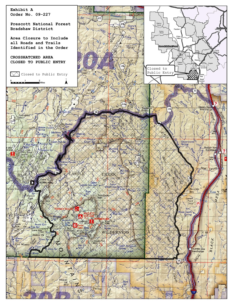
Closures: An area closure went into effect Wednesday, August 19 at 12:00 am (midnight) and includes Castle Creek Wilderness and Horsethief Basin Recreation Area including all recreation sites and summer homes. The follow area closure is established within the specific areas of the Prescott National Forest, Bradshaw Ranger District on all Forest Service lands as described below:
Castle Creek Wilderness in its entirety, including all Forest Service Trails within the wilderness boundary.
All areas east and south of County Road 59 from the intersection with Forest Road 52 (approximately 1.5 miles south Crown King, AZ; TlON, R l W, Sec 23) to the forest boundary at Turkey Creek bridge (Tl 1N, RlE, Sec 25).
All areas west of the Forest boundary from its intersection with County Road 59 at Turkey Creek Bridge (Tl lN, RlE, Sec 25) to the southeast boundary corner of the Forest (approximately 6 miles southwest of Bumble Bee, AZ; T9N, RlE, Sec 12).
All areas north of the Forest boundary from the southeast corner (approximately 6 miles southwest of Bumble Bee, AZ; T 9N, R lE, Sec 12) to its intersection with Forest Trail 233 (Lane Mountain Trail) in Copper Basin (T9N. RI W, Sec 10).
All areas south and east of Forest Trail 233 (Lane Mountain Trail) from its intersection with the southern Forest boundary (T9N, R 1W, Sec 10) to its intersection with Forest Road 100 (TlON, R lW, Sec 36).
All areas east of Forest Road 100 from i ts intersection with Forest Trail 233 (TlON, RlW, Sec 36) to its intersection with Forest 52 (TlON, RlW, Sec 36) and all areas east of Forest Road 52 to its intersection with County Road 59 (TlON, R lW, Sec 23).
The Horsethief Basin/Recreational Area, including:
Forest Road 52 (Senator Highway) is closed east of the Forest Road 100 intersection (TlON, R lW, Sec 36).
Forest Roads: 52F, 696, 696D, 697, 9632B
Forest Trails: 234, 203, 217
The closure order and accompanying map are available on the Prescott National Forest website at www.fs.usda.gov/prescott.
Community Concerns: The fire and smoke will be visible to the west of Sunset Point on I-17 for days to come. Please be cautious while driving the highways in the area. The fire will be visible from AZ State Highway 69 from Mayer to Cordes Junction and along I-17 from Cordes Junction to Black Canyon City. Drivers are encouraged to keep their curiosity at bay and eyes forward on the road.
Weather: The area forecast indicates several days of warm temperatures and no precipitation with light winds. There are indications of a return to more normal monsoon weather by Monday of next week.
Fire Information: The public can obtain fire information via the following:
Prescott National Forest Fire Information Hotline – 928-777-5799
Prescott National Forest Web Site – www.fs.fed.us/r3/prescott
Fire Information – 928-925-1111
If You Fly We Can’t – Drones near Wildfires Are Not Safe! Unauthorized unmanned aircraft system flights threaten firefighter safety and wild land fire suppression efforts. Know the law for flying drones at http://www.fs.fed.us/science-technology/fire/unmanned-aircraft-systems.
Read www.SedonaEye.com for daily news and interactive views!


Saw this on way back to cottonwood from BCC & that’s a BIG FIRE !! Stay safe!!
California issues State of Emergency
The governor of California has issued a state of emergency in Amador and Calveras counties for the Butte Wildfire and in Lake and Napa counties for the Valley Wildfire. Emergency prescription refill procedures are in place from 9/11/2015 through 10/112015 and 9/13/2015 through 10/13/2015 respectively.
For more information, please visit: http://www.tricare.mil/Resources/DisasterInfo.